
Nothing will bring you to your knees faster than looking down a 1000 foot cliff.
There are no guardrails on a majority of Trail Ridge road, the highest paved road in a U.S. national park. My daughter and I snake our way slowly along the narrow road seeing no other cars, feeling some mild effects of altitude as we crest 10,000 feet. We will eventually reach 12,000 feet while driving before descending back down to the trailhead. “I’m getting a headache, mom,” said Lmy daughter. “I have ibuprofen in my backpack. Can you reach it?” I responded. “No, can you pull over. I have to pee too”.
Unsure of where to pull over, I stop in the middle of the road, we open the car doors, squat and pee right there. The air is foggy in front of the headlights and cold enough to see my breath. At 4:30am we still have an hour on this road before we reach the trailhead. My daughter opens the trunk and pulls out my backpack. “It’s in the side zippered pocket” I tell her.
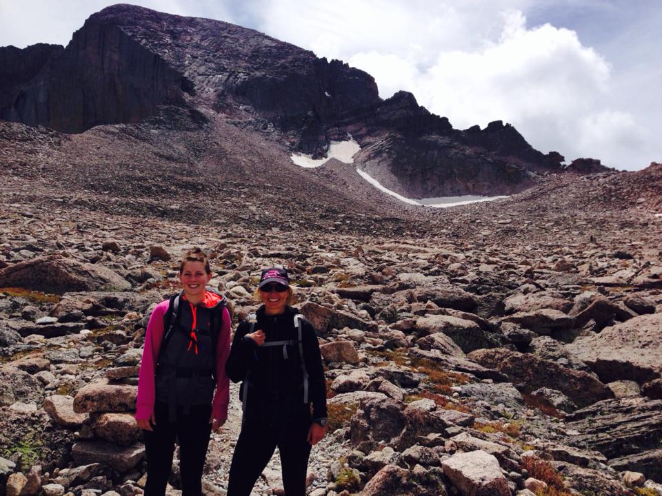
Back on the road again we talk about our excitement for the hike, a trek with over 5,100 feet of elevation gain over 7.4 miles one way. At 14.8 miles total, this is the longest, highest and most dangerous hike either of us have ever done, and it’s been over 20 years since either of us have been to Colorado. Longs Peak – the only fourteener in Rocky Mountain National Park was named after Stephen Long, an explorer in the area in the 1820’s. More beautiful than I remember, we spent the first few days hiking on lower elevation trails trying to adjust to the altitude. My daughter had been training for a trail marathon and was also in excellent shape, so we felt pretty confident in the hike, too confident. Longs is dubbed one of the most difficult Class 3 fourteeners in Colorado.
Arriving at the trailhead just before 5:30am, we see there are quite a few cars in the lot already. Looking toward the mountain, we can make out several tiny headlamps from hikers who started much earlier than us, many at 2:00am to ensure they had enough time to summit and descend before the threat of afternoon storms. Storms with lightning are common on the big mountains and it’s advised to summit by noon so you can descend into the treeline before any real danger. Many of these mountains create their own weather, and we’ve been watching the forecast for any threats. So far my weather app says the day will be clear, but that can change quickly. A rumble of thunder could mean a storm with hail and lightning within 15 minutes. We’ve been reading about the deaths on Longs Peak, which is considered Colorado’s deadliest mountain. One technical climber was struck by lightning on the diamond face, another hiker was overtaken by strong winds and fell 200 feet, others have died from hypothermia, cardiac events and exhaustion. This mountain is no joke, and we are humbled in the presence of it.
We hit the pit bathrooms, check our backpacks, turn on our headlamps and start toward the trailhead, stopping to take pictures of the maps in case we lose reception and a quick selfie of us before we start on this adventure. I have a backup map in my pack, but I’m being extra cautious. I have precious cargo with me, my daughter, and I’m about to take her up the deadliest mountain in the state.
The sunrise will be peaking over the mountain between 6:00 and 6:30am, so we will only have to hike with the headlamps for an hour or less, and the sun should also warm us up quickly. The thermometer in the rental car read 42 degrees, forcing us into hiking pants, hats, gloves and warm jackets. I start the timer on my sport watch and we are off, hiking the trail with a spring in our steps, giddy with excitement as we make our way past the shadows of large boulders and walls of soaring pine trees. Up ahead we can hear the river rushing down the mountain, bubbling over rocks and branches as it travels along its bed, and this is where we come to a rustic wooden bridge. I take the first step up, and then the second and third before I stop, holding the rails and staring at the narrow path before me. I can’t see the other side with my headlamp, but I trust the path will continue on the other side, the mountain waiting for me to come to her. I take a deep breath in and then exhale a “thank you” to the forest before continuing on. I will cross this bridge at 40 years of age, hoping and praying that my life will change but not fully understanding what I’m asking for. Not knowing that this bridge, this crossing over, will shape me in ways I can’t imagine.
The sun is peeking its golden head above the mountain tops, stretching its arms into the sky while it breathes good morning and fills the trail with light. We first remove our headlamps and gloves, and a few minutes later are ready to swap our winter hats for baseball caps. The sun has already increased the temperature by at least 10 degrees. Up, up, up we hike up switchbacks that appear to go on forever. I share with Lily that I went on a boring date with a guy named Adrian, who is also a triathlete. I laugh as I talk and that makes Lily smile. Lily is always happy for me when I am happy, and sad for me when I am sad. At 23, she is contemplating marriage to the boy she’s been dating since high school. He isn’t my perfect choice for her, but it’s not up to us mothers to choose spouses for our children, even if we’d like to. I will try to be supportive of this relationship if it makes her happy, I just have a suspicion (call it intuition) that she truly isn’t.
“I’m getting a little hungry”, I say. Looking at my watch we’ve only been hiking for 1.5 hours. I pull out a granola bar from the side pocket of my backpack and snack while we continue to climb higher up more switchbacks. I don’t want to take too many stops unless we need to, knowing we got a late start. “I think we are almost out of the switchbacks”, says Lily. “I didn’t think they would ever end.” We’ve come to another river crossing and this body of water is more than 5 times the size of the first, the water is moving very fast and does not include a bridge. We will need to boulder hop across.
I pull out my trail map and look at the photos on my phone, but I don’t immediately see where the trail picks up. We’ve spotted rock cairns (rock trail markers pronounced karens) in critical areas so far, so I’m not too worried, but once we navigate the river we lose the trail. After crossing the river we head north, which is toward the mountain, but the forest is getting thick. Whack. I feel a sudden pain in my head and realize I didn’t clear the tree branch above me. The bill of my hat had blocked my vision. “Fuuuuuck”, I yell and after 45 minutes we realize we are completely lost. I pull out my phone again and study the maps, trying to locate the river crossing and where we fell off the trail. I show the map to Lily, who’s frustrated bushwhacking through the trees, and realize we were supposed to go south a few hundred feet after crossing the river.
The time off trail would cost us dearly. We head out of the forest the same way we came until we are standing at the edge of the river. “According to the map we need to keep following the river south until the next rock cairn”, I say to Lily.
“I need to sit for a minute, mom”, she replies, and we do. We collect ourselves, drink more fluids and enjoy a few gummy bears before backtracking along the river until we see the rock cairns. Losing almost an hour, we have finally located the trail and are relieved to be back on track. Although we were literally 25 feet from the trail, we somehow managed to get lost. Lesson learned; follow the maps closely even if the trail seems straightforward.
As we near the end of the treeline near the open rock, I notice the trunks of the trees are twisted, a form of stunted, deformed vegetation often encountered in the subalpine. The different types of terrain we encounter is astounding. I can’t believe much of anything could live up here, it’s like being on the moon.
Ascending out of the treeline, Longs first comes into view. We are now above 11,000 feet and feeling the elevation. The dull headache is moving into a band that is tightening around my head. I pull out the ibuprofen and electrolyte pills. We heard about the electrolytes from another hiker back home, and he claimed they saved him from altitude sickness. We pop one of each pill, take a long drink from our camelback hoses and decide to sit on the side of the trail for a few minutes to catch our breath and stop the world from spinning. Lily pulls out a bag of gummy bears and offers me a handful. The sweet, sugary candy tastes like heaven. In fact, everything we eat on the trail tastes like heaven because we are so hungry.
After a 10 minute wait, we decide we feel good enough to continue on the trail heading into a forever span of vast open area of rock and tundra, up and around Mt Lady Washington, over Granite Pass and toward Storm Peak. Longs is still a long way away, and maybe that is why they call it Longs…because the path there is so long? The diamond face appears and disappears as we make our way closer, past the camping area and at the foot of the boulder field. This is when we realize that the hike so far has really been quite easy, well, not easy for us, but easy compared to what lies ahead. We’ve been hiking for just over 5 hours and decide it’s time for a hearty lunch before we attempt the boulders. At an elevation of 12,760 feet, the boulder field is an enormous wasteland of rocks that sits 500 feet below the famous Keyhole and 1,500 feet below the summit. The Keyhole is a notch cut out of the rock that you climb through to the other side before continuing on with the hike. It sits at 13,200 feet. Arriving at the Keyhole is a feat in itself, and decisions need to be made whether or not to continue from that point on. We spoke with a guide yesterday that gave us instructions on what to do, and what not to do, once we hit the Keyhole. There is still 1.5 miles and over 1,000 feet of climbing after the Keyhole and most of it consists of exposed narrow ledges where one slip can be a fatal fall of 100 feet or 1,000. The guide said to stop at the Keyhole, look at the time and assess the wind. If the time is past noon and wind is whipping on the other side after crossing through the notch, don’t summit. If the time is before noon and the wind is low, it is probably safe to summit if you have enough nutrition on board, are comfortable with the exposure, elevation and trail conditions. This is a lot to consider, especially as a flatlander who’s never been hiking at this elevation or on these types of trails. No amount of trail running or backpacking up ski hills can prepare us for this.
We step off the trail and sit our backpacks on the ground next to a few rocks large enough to provide seats. Unzipping the top pouch, we each pull out ziplock bags with the contents of our meal. Lunch consists of two peanut butter and honey sandwiches carefully wrapped in tinfoil, but still smushed, and an apple. As I peel back a corner and take a bite, I exclaim that it’s the best sandwich I’ve ever consumed and Lily agrees. For the next ten minutes we are in peanut butter heaven, soaking up the sunshine and the glorious mountain views.
Next up is the boulder field. At this point there is no trail and you hike, climb, jump, crawl or scramble – basically whatever it takes – over enormous boulders, slowly making your way to the Keyhole which sits at 13,200 feet. The goal was to make it to the Keyhole well before noon, and assess the weather, but with the late start and getting lost after the creek we quickly realized we may not summit today. The hike to the summit would be another 2 hours with over 1,000 feet of climb through class 3 terrain after the Keyhole, and another 2 hours down since the hike is so technical. If we would have started the route at 2:00am we might have had a chance, but not this late in the game. Today, we would hike to the Keyhole and turn around, hoping to someday return and summit Longs.
The weather was much colder nearing the boulder field, prompting us to stop and add layers, including thin gloves, despite the fact it was July and sunny. It’s common for snow to remain on the high mountains year round.
The boulder field was much more difficult and energy zapping than we realized. Each boulder hop required us to rest for a few seconds to catch our breath before continuing on to the next one. And we wanted to make sure we had our wits about us because falling between the boulders could mean a sprained ankle or broken leg. Our progress was slow, even more so when we truly started climbing, inserting our gloved fingers and toes into small notches where the rock face was split. With less than 200 yards to the Keyhole, my daughter wedged her hip between two rocks and told me she couldn’t go any further. It was just getting to be too difficult and she was exhausted from nearly 7 hours of hiking/climbing. “I want you to go Mom, you need to stand in the Keyhole and take pictures for me. I’m safe right here and I can see you, I’ll wait.”
“No way. I will wait until you feel ready.” I replied.
“I can’t. I’m scared to go any higher. Go take a few pictures and let’s head down”, said my daughter.
This put me in a tough spot. I would normally never separate from my daughter, or anyone I’m with, on a hike. But with less than 200 yards we would be able to see each other the entire time.

“Are you sure you’re okay right here?”, I asked my daughter.
“Yeah. I’m going to have a snack, take some ibuprofen and drink more. My fingers look like sausages from the elevation.” she replied.
And so I continued with the climb, up over the boulders and up to the Agnes Vaille Shelter. Shaped like a beehive, it is built from stones into the side of the mountain. It was first built in 1927 by the National Park Service after a number of climbers died ascending Longs Peak. I took a few photos, looked down at my daughter to make sure she was okay, and kept moving. It was nearing 1:00pm.
The final push up into the Keyhole revealed a flat ledge, something like a balcony of rock, where I could stand and take photos. To summit Longs, you climb through the Keyhole to the other side and snake your way up the other side of the mountain. I was now standing on that balcony, alone, facing snow capped mountain peaks in every direction and alpine lakes resting 2000 feet below at the bases. The views of Powell Peak, McHenry Peak, Glacier Gorge and Black Lake were outstanding. I was humbled, and a little nauseous. 1000+ feet of drop without a guardrail was like nothing I had ever experienced. To think that this type of beauty exists in this world, and we were climbing on it for fun. I inhaled the mountain air and exhaled tears, the last four years of heartache and uncertainty spilling out onto the rock. In that moment, the fullness of God and the Universe penetrated my soul in a way I had never experienced in a church pew or on my knees in prayer. The mountain was my church and my soul was singing. “Thank you”, I said in a whimper, the wind lifting my words up past the peaks and to the heavens.
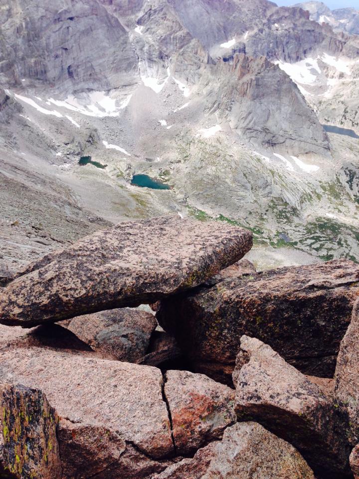
I turned to my left to see the extremely long and narrow trail I would not be climbing, called the Ledges, next to the dropoff. Red and yellow bullseyes mark the way so as to not get lost. It was surreal. On a busy summer day, there will be people all over this steep and rocky area. If there is snow, it can be deadly. Past the Ledges you come to the Trough, a steep, narrow gully that ascends 600 feet. Many people put helmets on in this section, but I doubt the helmet will do much if you take that tumble. Once you’ve climbed the Trough, you are now at an area called the Narrows. The Narrows is the most intimidating section of the climb for most people. About 1,000 feet of narrow ledge (3 feet wide at one point) that hugs a 1,000 foot rising wall on your left and a 500 foot drop to your right. I’ve studied this route for hours on end in hopes we would be able to summit, but at this point on our journey I feel relieved to turn around. We still have a long way down.
Reluctantly I turn away, not wanting to let go of the magic before me. I head back through the Keyhole and slowly spider climb my way to my daughter. She’s beaming at me and asks, “How was it?”
“Incredible.” I replied. “It was just so beautiful. I can’t wait to do this again.”
